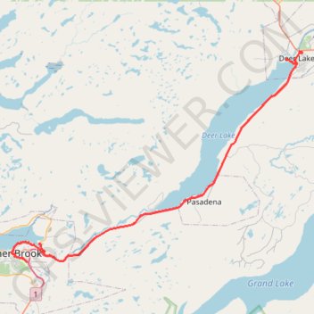
Corner Brook - Deer Lake
#Bike #CornerBrook #Deer #Newfoundland
- Distance: 64.2 Km
- Elevation gain: 446 m
- Maximum elevation: 137 m
- Elevation loss: 564 m
- Minimum elevation: 0 m
Interactive trail map
Trail profile
- Distance: 64.2 Km
- Elevation gain: 446 m
- Maximum elevation: 137 m
- Elevation loss: 564 m
- Minimum elevation: 0 m
About this trail
Name: Corner Brook - Deer Lake trail, distance, elevation, map, profile, GPS track
Coordinates: 48.94224 -57.94531 49.19092 -57.42223
Other hiking, mountain biking, running and outdoor activity trails
Click on a trail to view its statistics, map and profile.
Robinson's Junction - Corner Brook
Canada > Newfoundland and Labrador
Distance: 111.3 Km • Elevation gain: 1,156 m • Maximum elevation: 314 m
Deer Lake - Sheppardville
Canada > Newfoundland and Labrador > Reidville
#Bike #Deer #Sheppardville #Newfoundland
Distance: 96.0 Km • Elevation gain: 529 m • Maximum elevation: 153 m