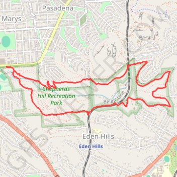
Shepherds Hill Recreation Park - Waitparinga Reserve
Interactive trail map
Trail profile
- Distance: 8.5 Km
- Elevation gain: 246 m
- Maximum elevation: 236 m
- Elevation loss: 246 m
- Minimum elevation: 71 m
About this trail
Name: Shepherds Hill Recreation Park - Waitparinga Reserve trail, distance, elevation, map, profile, GPS track
Coordinates: -35.01809 138.57975 -35.01041 138.60833
Topography: Adelaide topographic map, elevation, terrain
Other hiking, mountain biking, running and outdoor activity trails
Click on a trail to view its statistics, map and profile.
Brighton - Adelaide
Australia > South Australia > Adelaide
#Bike
Distance: 23.4 Km • Elevation gain: 101 m • Maximum elevation: 53 m