Thank you for supporting this site ❤️
Make a donation
Make a donation
Gear up for your next adventure:
As an Amazon Associate, this site earns from qualifying purchases at no extra cost to you.
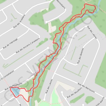
Rivière des Roches Loop
#Hiking #Running #Snowshoeing #Loop
- Distance: 2.2 Km
- Elevation gain: 35 m
- Maximum elevation: 196 m
- Elevation loss: 35 m
- Minimum elevation: 162 m
Interactive trail map
Thank you for supporting this site ❤️
Make a donation
Make a donation
Gear up for your next adventure:
As an Amazon Associate, this site earns from qualifying purchases at no extra cost to you.
Trail profile
- Distance: 2.2 Km
- Elevation gain: 35 m
- Maximum elevation: 196 m
- Elevation loss: 35 m
- Minimum elevation: 162 m
Thank you for supporting this site ❤️
Make a donation
Make a donation
Gear up for your next adventure:
As an Amazon Associate, this site earns from qualifying purchases at no extra cost to you.
About this trail
Name: Rivière des Roches Loop trail, distance, elevation, map, profile, GPS track
Coordinates: 46.89352 -71.29198 46.89959 -71.28424
Thank you for supporting this site ❤️
Make a donation
Make a donation
Gear up for your next adventure:
As an Amazon Associate, this site earns from qualifying purchases at no extra cost to you.