Make a donation
Gear up for your next adventure:
As an Amazon Associate, this site earns from qualifying purchases at no extra cost to you.
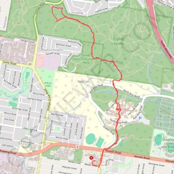
Toohey Forest Conservation Park
Interactive trail map
Make a donation
Gear up for your next adventure:
As an Amazon Associate, this site earns from qualifying purchases at no extra cost to you.
Trail profile
- Distance: 8.9 Km
- Elevation gain: 154 m
- Maximum elevation: 104 m
- Elevation loss: 157 m
- Minimum elevation: 35 m
- Moving time: 1 h 37 m
- Moving speed: 5.5 Km/h
- Maximum speed: 34.4 Km/h
- Total time: 1 h 38 m
- Global speed: 5.4 Km/h
Make a donation
Gear up for your next adventure:
As an Amazon Associate, this site earns from qualifying purchases at no extra cost to you.
About this trail
Name: Toohey Forest Conservation Park trail, distance, elevation, map, profile, GPS track
Start: Middle Street, Coopers Plains, Greater Brisbane, Queensland, 4108, Australia (-27.56031 153.04950)
Coordinates: -27.56132 153.04218 -27.53716 153.05401
Topography: Queensland topographic map, elevation, terrain
Make a donation
Gear up for your next adventure:
As an Amazon Associate, this site earns from qualifying purchases at no extra cost to you.
Other hiking, mountain biking, running and outdoor activity trails
Click on a trail to view its statistics, map and profile.
Gravel loop ride via Karawatha
Australia > Queensland > City of Brisbane
Distance: 60.4 Km • Elevation gain: 620 m • Maximum elevation: 110 m
Toohey Forest Loop
Australia > Queensland > City of Brisbane
Distance: 7.9 Km • Elevation gain: 185 m • Maximum elevation: 110 m
Mount Gravatt and Toohey Foret Loop
Australia > Queensland > Brisbane
Distance: 26.1 Km • Elevation gain: 785 m • Maximum elevation: 187 m
Make a donation
Gear up for your next adventure:
As an Amazon Associate, this site earns from qualifying purchases at no extra cost to you.
Brisbane - Karawatha
Distance: 22.2 Km • Elevation gain: 239 m • Maximum elevation: 89 m