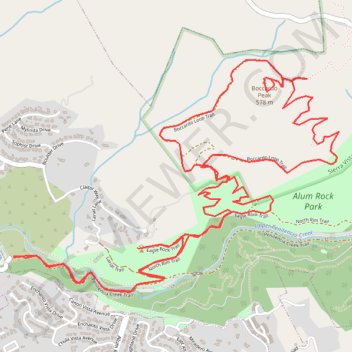
Boccardo Peak and Eagle Rock Loop
Starting near Upper Penitencia Creek, this loop follows the Penitencia Creek Trail through Alum Rock Park’s canyon setting before climbing onto the North Rim Trail, where the route opens toward Eagle Rock and broader views over San José and the South Bay foothills.
From Eagle Rock, the hike continues onto Todd L. Quick Trail, leaving the creek corridor for the rolling grasslands, oak woodland, and chaparral of Sierra Vista Open Space Preserve.
The Boccardo Loop Trail then circles the higher hills, with a short summit spur to Boccardo Peak, before the route retraces toward Todd L. Quick Trail, North Rim Trail, and the shaded Penitencia Creek corridor back to the start.
#Hiking #Loop #Mountain #Rock #Nature #Forest #Park #Creek #Canyon #Grassland #Views #Summit
- Distance: 12.3 Km
- Elevation gain: 595 m
- Maximum elevation: 574 m
- Elevation loss: 595 m
- Minimum elevation: 102 m
- Moving time: 3 h 32 m
- Moving speed: 3.5 Km/h
- Maximum speed: 6.4 Km/h
- Total time: 4 h 29 m
- Global speed: 2.7 Km/h
Interactive trail map
Trail profile
- Distance: 12.3 Km
- Elevation gain: 595 m
- Maximum elevation: 574 m
- Elevation loss: 595 m
- Minimum elevation: 102 m
- Moving time: 3 h 32 m
- Moving speed: 3.5 Km/h
- Maximum speed: 6.4 Km/h
- Total time: 4 h 29 m
- Global speed: 2.7 Km/h
About this trail
Name: Boccardo Peak and Eagle Rock Loop trail, distance, elevation, map, profile, GPS track
Coordinates: 37.39341 -121.82507 37.40684 -121.80136