Ten Sleep French Cattle Ranch Approach Long
Washakie County Hiking
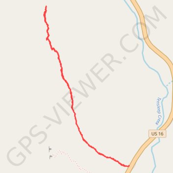
- Distance: 3.3 Km
- Elevation gain: 194 m
- Maximum elevation: 2,440 m
- Elevation loss: 194 m
- Minimum elevation: 2,254 m
- Moving time: 53 m 35 s
- Moving speed: 3.6 Km/h
- Maximum speed: 5.6 Km/h
- Total time: 3 h 49 m
- Global speed: 0.9 Km/h
Interactive trail map
Trail profile
- Distance: 3.3 Km
- Elevation gain: 194 m
- Maximum elevation: 2,440 m
- Elevation loss: 194 m
- Minimum elevation: 2,254 m
- Moving time: 53 m 35 s
- Moving speed: 3.6 Km/h
- Maximum speed: 5.6 Km/h
- Total time: 3 h 49 m
- Global speed: 0.9 Km/h
About this trail
Name: Ten Sleep French Cattle Ranch Approach Long trail, distance, elevation, map, profile, GPS track
Start: French Cattle Ranch Approach, Washakie County, Wyoming, 80000, United States (44.13555 -107.25011)
End: US 16, Washakie County, Wyoming, United States (44.13559 -107.24994)
Coordinates: 44.13551 -107.25810 44.14654 -107.24993