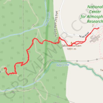
Mallory Cave Trail via NCAR Trail and Table Mountain
The Mallory Cave Trail via the NCAR and Table Mountain offers a rewarding hike through Boulder’s iconic foothills. Starting from the NCAR campus, the trail winds through open meadows, offering striking views of the Flatirons and red rock formations. The final section involves a challenging scramble up to the cave, which remains closed to protect local bat populations, but the panoramic scenery along the route makes the effort worthwhile. #Hiking #Mountain #Forest #Nature #Cave
- Distance: 4.6 Km
- Elevation gain: 284 m
- Maximum elevation: 2,080 m
- Elevation loss: 284 m
- Minimum elevation: 1,852 m
- Moving time: 1 h 29 m
- Moving speed: 3.1 Km/h
- Maximum speed: 6.0 Km/h
- Total time: 1 h 59 m
- Global speed: 2.3 Km/h
Interactive trail map
Trail profile
- Distance: 4.6 Km
- Elevation gain: 284 m
- Maximum elevation: 2,080 m
- Elevation loss: 284 m
- Minimum elevation: 1,852 m
- Moving time: 1 h 29 m
- Moving speed: 3.1 Km/h
- Maximum speed: 6.0 Km/h
- Total time: 1 h 59 m
- Global speed: 2.3 Km/h
About this trail
Name: Mallory Cave Trail via NCAR Trail and Table Mountain trail, distance, elevation, map, profile, GPS track
Start: NCAR Road, Boulder, Boulder County, Colorado, 80305, United States (39.97925 -105.27418)
End: NCAR Road, Boulder, Boulder County, Colorado, 80305, United States (39.97927 -105.27418)
Coordinates: 39.97355 -105.28924 39.97927 -105.27418
Other hiking, mountain biking, running and outdoor activity trails
Click on a trail to view its statistics, map and profile.
Bear Peak
United States > Colorado > Boulder County > Boulder
Starting at the National Center for Atmospheric Research trailhead, the hike leaves the campus edge on the N.C.A.R. Trail and crosses the open Table Mountain foothills toward the Mesa Trail, with the Flatirons rising to the west above Boulder Open Space and Mountain Parks. It then follows the Mesa Trail south…
Distance: 4.7 Km • Elevation gain: 743 m • Maximum elevation: 2,543 m