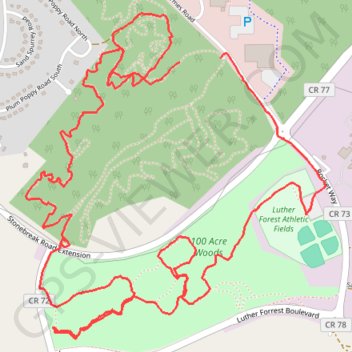
100 acre woods
- Distance: 8.8 Km
- Elevation gain: 123 m
- Maximum elevation: 109 m
- Elevation loss: 120 m
- Minimum elevation: 72 m
- Moving time: 1 h 37 m
- Moving speed: 5.4 Km/h
- Maximum speed: 12.6 Km/h
- Total time: 1 h 42 m
- Global speed: 5.2 Km/h
Interactive trail map
Trail profile
- Distance: 8.8 Km
- Elevation gain: 123 m
- Maximum elevation: 109 m
- Elevation loss: 120 m
- Minimum elevation: 72 m
- Moving time: 1 h 37 m
- Moving speed: 5.4 Km/h
- Maximum speed: 12.6 Km/h
- Total time: 1 h 42 m
- Global speed: 5.2 Km/h
About this trail
Name: 100 acre woods trail, distance, elevation, map, profile, GPS track
Start: Main Loop, Town of Malta, Saratoga County, New York, 12151, United States (42.96605 -73.76922)
End: Main Loop, Town of Malta, Saratoga County, New York, 12151, United States (42.96618 -73.76706)
Coordinates: 42.95518 -73.77746 42.96796 -73.76143
Other hiking, mountain biking, running and outdoor activity trails
Click on a trail to view its statistics, map and profile.