Thank you for supporting this site ❤️
Make a donation
Make a donation
Gear up for your next adventure:
As an Amazon Associate, this site earns from qualifying purchases at no extra cost to you.
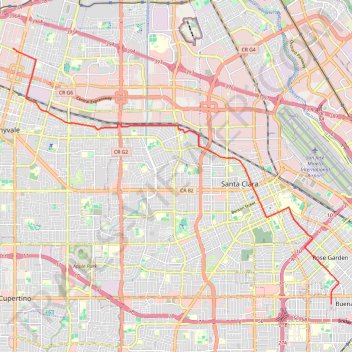
Activity
- Distance: 16.1 Km
- Elevation gain: 30 m
- Maximum elevation: 36 m
- Elevation loss: 48 m
- Minimum elevation: 14 m
- Moving time: 46 m 36 s
- Moving speed: 20.7 Km/h
- Maximum speed: 31.4 Km/h
- Total time: 46 m 36 s
- Global speed: 20.7 Km/h
Interactive trail map
Thank you for supporting this site ❤️
Make a donation
Make a donation
Gear up for your next adventure:
As an Amazon Associate, this site earns from qualifying purchases at no extra cost to you.
Trail profile
- Distance: 16.1 Km
- Elevation gain: 30 m
- Maximum elevation: 36 m
- Elevation loss: 48 m
- Minimum elevation: 14 m
- Moving time: 46 m 36 s
- Moving speed: 20.7 Km/h
- Maximum speed: 31.4 Km/h
- Total time: 46 m 36 s
- Global speed: 20.7 Km/h
Thank you for supporting this site ❤️
Make a donation
Make a donation
Gear up for your next adventure:
As an Amazon Associate, this site earns from qualifying purchases at no extra cost to you.
About this trail
Name: Activity trail, distance, elevation, map, profile, GPS track
Coordinates: 37.32128 -122.03286 37.39107 -121.92115
Thank you for supporting this site ❤️
Make a donation
Make a donation
Gear up for your next adventure:
As an Amazon Associate, this site earns from qualifying purchases at no extra cost to you.
Other hiking, mountain biking, running and outdoor activity trails
Click on a trail to view its statistics, map and profile.
Guadalupe River Trail and various flooding detours, San Jose
United States > California > Santa Clara County > San Jose
Distance: 29.4 Km • Elevation gain: 79 m • Maximum elevation: 31 m