Thank you for supporting this site ❤️
Make a donation
Make a donation
Gear up for your next adventure:
As an Amazon Associate, this site earns from qualifying purchases at no extra cost to you.
Wild Bank
Tameside Hiking
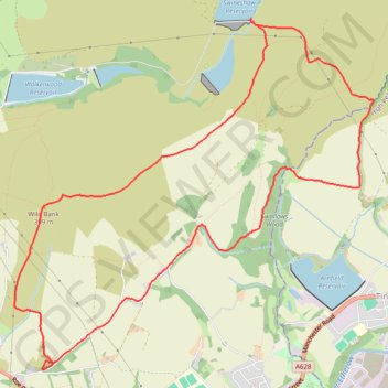
- Distance: 11.0 Km
- Elevation gain: 303 m
- Maximum elevation: 398 m
- Elevation loss: 303 m
- Minimum elevation: 187 m
- Moving time: 2 h 51 m
- Moving speed: 3.8 Km/h
- Maximum speed: 7.7 Km/h
- Total time: 3 h 51 m
- Global speed: 2.8 Km/h
Interactive trail map
Thank you for supporting this site ❤️
Make a donation
Make a donation
Gear up for your next adventure:
As an Amazon Associate, this site earns from qualifying purchases at no extra cost to you.
Trail profile
- Distance: 11.0 Km
- Elevation gain: 303 m
- Maximum elevation: 398 m
- Elevation loss: 303 m
- Minimum elevation: 187 m
- Moving time: 2 h 51 m
- Moving speed: 3.8 Km/h
- Maximum speed: 7.7 Km/h
- Total time: 3 h 51 m
- Global speed: 2.8 Km/h
Thank you for supporting this site ❤️
Make a donation
Make a donation
Gear up for your next adventure:
As an Amazon Associate, this site earns from qualifying purchases at no extra cost to you.
About this trail
Name: Wild Bank trail, distance, elevation, map, profile, GPS track
Coordinates: 53.46626 -2.02208 53.49309 -1.97599
Thank you for supporting this site ❤️
Make a donation
Make a donation
Gear up for your next adventure:
As an Amazon Associate, this site earns from qualifying purchases at no extra cost to you.
Other hiking, mountain biking, running and outdoor activity trails
Click on a trail to view its statistics, map and profile.
Wild Bank - Higher Swineshaw Reservoir - Swallows Wood - Loop
United Kingdom > England > Tameside > Mottram > Stalyhill
Distance: 10.9 Km • Elevation gain: 311 m • Maximum elevation: 398 m