Thank you for supporting this site ❤️
Make a donation
Make a donation
Gear up for your next adventure:
As an Amazon Associate, this site earns from qualifying purchases at no extra cost to you.
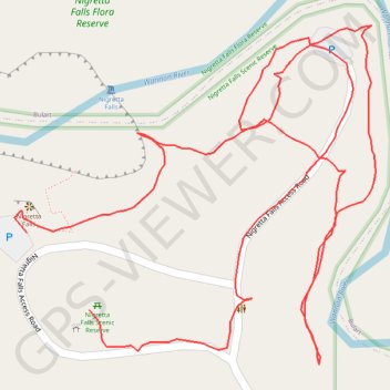
Nigretta Falls
- Distance: 1.5 Km
- Elevation gain: 27 m
- Maximum elevation: 171 m
- Elevation loss: 21 m
- Minimum elevation: 150 m
- Moving time: 25 m 27 s
- Moving speed: 3.4 Km/h
- Maximum speed: 33.3 Km/h
- Total time: 42 m 17 s
- Global speed: 2.1 Km/h
Interactive trail map
Thank you for supporting this site ❤️
Make a donation
Make a donation
Gear up for your next adventure:
🧦Merino Wool Hiking Socks - Moisture-wicking socks to prevent blisters during long topographic surveys
As an Amazon Associate, this site earns from qualifying purchases at no extra cost to you.
Trail profile
- Distance: 1.5 Km
- Elevation gain: 27 m
- Maximum elevation: 171 m
- Elevation loss: 21 m
- Minimum elevation: 150 m
- Moving time: 25 m 27 s
- Moving speed: 3.4 Km/h
- Maximum speed: 33.3 Km/h
- Total time: 42 m 17 s
- Global speed: 2.1 Km/h
Thank you for supporting this site ❤️
Make a donation
Make a donation
Gear up for your next adventure:
As an Amazon Associate, this site earns from qualifying purchases at no extra cost to you.
About this trail
Name: Nigretta Falls trail, distance, elevation, map, profile, GPS track
Coordinates: -37.65757 141.92382 -37.65533 141.92683
Topography: Victoria topographic map, elevation, terrain
Thank you for supporting this site ❤️
Make a donation
Make a donation
Gear up for your next adventure:
As an Amazon Associate, this site earns from qualifying purchases at no extra cost to you.