
Bear Peak via Shanahan Trail and Fern Canyon Trail
The Bear Peak hike via Shanahan and Fern Canyon Trails in City of Boulder Open Space and Mountain Parks offers a challenging ascent with rewarding panoramic views. Along the way, hikers encounter a steep climb through varied terrain, including rocky paths and dense forests. Upon reaching the summit, the vistas encompass the city of Boulder, the Flatirons, and the Continental Divide. This route is well-suited for experienced hikers seeking a strenuous yet scenic adventure. #Hiking #Mountain #Forest #Nature
- Distance: 7.9 Km
- Elevation gain: 789 m
- Maximum elevation: 2,545 m
- Elevation loss: 789 m
- Minimum elevation: 1,755 m
- Moving time: 2 h 44 m
- Moving speed: 2.9 Km/h
- Maximum speed: 5.4 Km/h
- Total time: 2 h 51 m
- Global speed: 2.8 Km/h
Interactive trail map
Trail profile
- Distance: 7.9 Km
- Elevation gain: 789 m
- Maximum elevation: 2,545 m
- Elevation loss: 789 m
- Minimum elevation: 1,755 m
- Moving time: 2 h 44 m
- Moving speed: 2.9 Km/h
- Maximum speed: 5.4 Km/h
- Total time: 2 h 51 m
- Global speed: 2.8 Km/h
About this trail
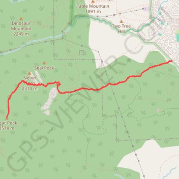
Name: Bear Peak via Shanahan Trail and Fern Canyon Trail trail, distance, elevation, map, profile, GPS track
Start: Cragmoor Connector, Boulder, Boulder County, Colorado, 80305, United States (39.96864 -105.26341)
End: Cragmoor Connector, Boulder, Boulder County, Colorado, 80305, United States (39.96864 -105.26338)
Coordinates: 39.96028 -105.29521 39.96864 -105.26338
Other hiking, mountain biking, running and outdoor activity trails
Click on a trail to view its statistics, map and profile.
Bear Peak
United States > Colorado > Boulder County > Boulder
Starting at the National Center for Atmospheric Research trailhead, the hike leaves the campus edge on the N.C.A.R. Trail and crosses the open Table Mountain foothills toward the Mesa Trail, with the Flatirons rising to the west above Boulder Open Space and Mountain Parks. It then follows the Mesa Trail south…
Distance: 4.7 Km • Elevation gain: 743 m • Maximum elevation: 2,543 m