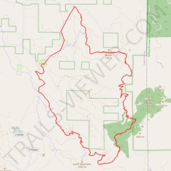
Backpacked Tarbell Loop Trail
- Distance: 45.9 Km
- Elevation gain: 1,760 m
- Maximum elevation: 1,010 m
- Elevation loss: 1,752 m
- Minimum elevation: 333 m
- Moving time: 11 h 33 m
- Moving speed: 4.0 Km/h
- Maximum speed: 10.8 Km/h
- Total time: 2 d 1 h
- Global speed: 0.9 Km/h
Interactive trail map
Trail profile
- Distance: 45.9 Km
- Elevation gain: 1,760 m
- Maximum elevation: 1,010 m
- Elevation loss: 1,752 m
- Minimum elevation: 333 m
- Moving time: 11 h 33 m
- Moving speed: 4.0 Km/h
- Maximum speed: 10.8 Km/h
- Total time: 2 d 1 h
- Global speed: 0.9 Km/h
About this trail
Name: Backpacked Tarbell Loop Trail trail, distance, elevation, map, profile, GPS track
Start: Tarbell Trailhead, L-1100 Road, Clark County, Washington, United States (45.79306 -122.30170)
End: Tarbell Access Trail, Clark County, Washington, United States (45.79270 -122.30110)
Coordinates: 45.71503 -122.32865 45.79306 -122.25778
Other hiking, mountain biking, running and outdoor activity trails
Click on a trail to view its statistics, map and profile.
Expedition to Sedum Ridge
United States > Oregon > Multnomah County > Portland
Distance: 214.7 Km • Elevation gain: 5,093 m • Maximum elevation: 1,169 m