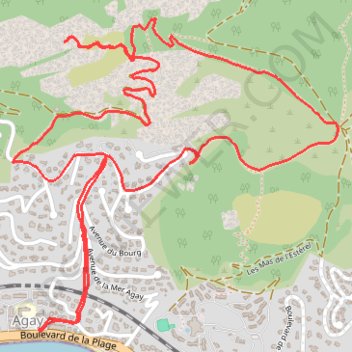
Agay - Rastel d Agay
- Distance: 6.3 Km
- Elevation gain: 293 m
- Maximum elevation: 264 m
- Elevation loss: 293 m
- Minimum elevation: 2 m
Interactive trail map
Trail profile
- Distance: 6.3 Km
- Elevation gain: 293 m
- Maximum elevation: 264 m
- Elevation loss: 293 m
- Minimum elevation: 2 m
About this trail
Name: Agay - Rastel d Agay trail, distance, elevation, map, profile, GPS track
Coordinates: 43.43436 6.86254 43.44448 6.87702
Other hiking, mountain biking, running and outdoor activity trails
Click on a trail to view its statistics, map and profile.
1 LUCENA - MONTPELLIER
Distance: 2,964.4 Km • Elevation gain: 29,500 m • Maximum elevation: 1,048 m
PT23DS2 Lörrach → Cadaqués
Germany > Baden-Württemberg > Landkreis Lörrach > Lörrach (Kernstadt)
Distance: 1,050.7 Km • Elevation gain: 13,130 m • Maximum elevation: 1,505 m