Blackwood Grassland Loop Walk
- Distance: 1.5 Km
- Elevation gain: 29 m
- Maximum elevation: 233 m
- Elevation loss: 28 m
- Minimum elevation: 205 m
- Moving time: 21 m 17 s
- Moving speed: 4.1 Km/h
- Maximum speed: 7.5 Km/h
- Total time: 21 m 17 s
- Global speed: 4.1 Km/h
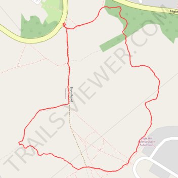
Interactive trail map
Trail profile
- Distance: 1.5 Km
- Elevation gain: 29 m
- Maximum elevation: 233 m
- Elevation loss: 28 m
- Minimum elevation: 205 m
- Moving time: 21 m 17 s
- Moving speed: 4.1 Km/h
- Maximum speed: 7.5 Km/h
- Total time: 21 m 17 s
- Global speed: 4.1 Km/h
About this trail
Name: Blackwood Grassland Loop Walk trail, distance, elevation, map, profile, GPS track
Start: Bryn Road, Pengam, Caerphilly County Borough, Wales, NP12 1SL, United Kingdom (51.66022 -3.20805)
End: Bryn Road, Pengam, Caerphilly County Borough, Wales, NP12 1SL, United Kingdom (51.66027 -3.20805)
Coordinates: 51.65682 -3.20977 51.66069 -3.20444
Other hiking, mountain biking, running and outdoor activity trails
Click on a trail to view its statistics, map and profile.
The Headstock 500
United Kingdom > Wales > Newport > Newport
Distance: 483.5 Km • Elevation gain: 9,616 m • Maximum elevation: 691 m