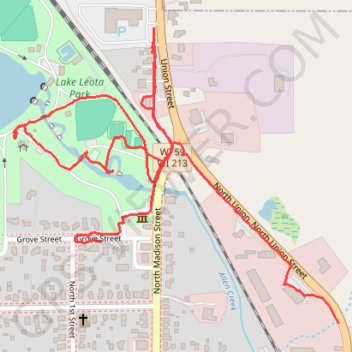
Lake Leota Park
- Distance: 2.7 Km
- Elevation gain: 22 m
- Maximum elevation: 284 m
- Elevation loss: 17 m
- Minimum elevation: 274 m
- Moving time: 46 m 24 s
- Moving speed: 3.5 Km/h
- Maximum speed: 5.8 Km/h
- Total time: 55 m 54 s
- Global speed: 2.9 Km/h
Interactive trail map
Trail profile
- Distance: 2.7 Km
- Elevation gain: 22 m
- Maximum elevation: 284 m
- Elevation loss: 17 m
- Minimum elevation: 274 m
- Moving time: 46 m 24 s
- Moving speed: 3.5 Km/h
- Maximum speed: 5.8 Km/h
- Total time: 55 m 54 s
- Global speed: 2.9 Km/h
About this trail
Name: Lake Leota Park trail, distance, elevation, map, profile, GPS track
End: 27, Grove Street, Evansville, Rock County, Wisconsin, 53536, United States (42.78341 -89.30056)
Coordinates: 42.78189 -89.30278 42.78733 -89.29463