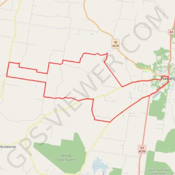
Goodger to Nanango
Goodger, Kunioon, Brooklands, South Nanango, Nanango, Barker Creek Flat, Queensland
- Distance: 52.0 Km
- Elevation gain: 584 m
- Maximum elevation: 505 m
- Elevation loss: 584 m
- Minimum elevation: 347 m
Interactive trail map
Trail profile
- Distance: 52.0 Km
- Elevation gain: 584 m
- Maximum elevation: 505 m
- Elevation loss: 584 m
- Minimum elevation: 347 m
About this trail
Name: Goodger to Nanango trail, distance, elevation, map, profile, GPS track
Start: Kingaroy Cooyar Road, Goodger, South Burnett Regional, Queensland, Australia (-26.65643 151.81926)
End: Kingaroy Cooyar Road, Goodger, South Burnett Regional, Queensland, Australia (-26.65644 151.81923)
Coordinates: -26.71749 151.81657 -26.64657 152.00138
Topography: Queensland topographic map, elevation, terrain
Other hiking, mountain biking, running and outdoor activity trails
Click on a trail to view its statistics, map and profile.
Ushers Hill and Archookoora State Forest loop
Distance: 52.6 Km • Elevation gain: 655 m • Maximum elevation: 563 m
Goodger to Ellesmere and Archookoora State Forest
Goodger, Brooklands, Ellesmere, Haly Creek, Archookoora, Queensland
Distance: 47.8 Km • Elevation gain: 622 m • Maximum elevation: 551 m
Kingaroy to Goodger Queensland
Australia > Queensland > Kingaroy
Goodger, Taabinga, Kingaroy, Boonenne, Queensland
Distance: 38.4 Km • Elevation gain: 300 m • Maximum elevation: 542 m
Hodgleigh and Nanango Loop
Distance: 37.3 Km • Elevation gain: 433 m • Maximum elevation: 465 m