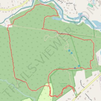
Lynnfield Woodlot and Willis Woods loop
- Distance: 5.1 Km
- Elevation gain: 45 m
- Maximum elevation: 50 m
- Elevation loss: 45 m
- Minimum elevation: 18 m
- Moving time: 1 h 8 m
- Moving speed: 4.5 Km/h
- Maximum speed: 9.9 Km/h
- Total time: 1 h 14 m
- Global speed: 4.1 Km/h
Interactive trail map
Trail profile
- Distance: 5.1 Km
- Elevation gain: 45 m
- Maximum elevation: 50 m
- Elevation loss: 45 m
- Minimum elevation: 18 m
- Moving time: 1 h 8 m
- Moving speed: 4.5 Km/h
- Maximum speed: 9.9 Km/h
- Total time: 1 h 14 m
- Global speed: 4.1 Km/h
About this trail
Name: Lynnfield Woodlot and Willis Woods loop trail, distance, elevation, map, profile, GPS track
Start: Lynnfield Woodlot, Lynnfield, Essex County, Massachusetts, 01949, United States (42.56362 -71.03835)
End: Lynnfield Woodlot, Lynnfield, Essex County, Massachusetts, 01949, United States (42.56347 -71.03842)
Coordinates: 42.56292 -71.04836 42.57314 -71.03548