Thank you for supporting this site ❤️
Make a donation
Make a donation
Gear up for your next adventure:
As an Amazon Associate, this site earns from qualifying purchases at no extra cost to you.
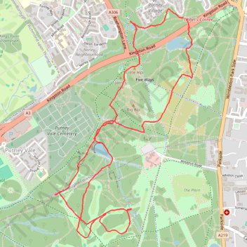
Wimbledon Common
- Distance: 6.3 Km
- Elevation gain: 68 m
- Maximum elevation: 56 m
- Elevation loss: 67 m
- Minimum elevation: 31 m
- Moving time: 57 m 49 s
- Moving speed: 6.5 Km/h
- Maximum speed: 14.6 Km/h
- Total time: 58 m 45 s
- Global speed: 6.4 Km/h
Interactive trail map
Thank you for supporting this site ❤️
Make a donation
Make a donation
Gear up for your next adventure:
As an Amazon Associate, this site earns from qualifying purchases at no extra cost to you.
Trail profile
- Distance: 6.3 Km
- Elevation gain: 68 m
- Maximum elevation: 56 m
- Elevation loss: 67 m
- Minimum elevation: 31 m
- Moving time: 57 m 49 s
- Moving speed: 6.5 Km/h
- Maximum speed: 14.6 Km/h
- Total time: 58 m 45 s
- Global speed: 6.4 Km/h
Thank you for supporting this site ❤️
Make a donation
Make a donation
Gear up for your next adventure:
As an Amazon Associate, this site earns from qualifying purchases at no extra cost to you.
About this trail
Name: Wimbledon Common trail, distance, elevation, map, profile, GPS track
Coordinates: 51.43211 -0.24223 51.44744 -0.22743
Thank you for supporting this site ❤️
Make a donation
Make a donation
Gear up for your next adventure:
As an Amazon Associate, this site earns from qualifying purchases at no extra cost to you.