Thank you for supporting this site ❤️
Make a donation
Make a donation
Gear up for your next adventure:
As an Amazon Associate, this site earns from qualifying purchases at no extra cost to you.
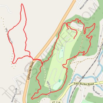
Kingdom Campground Loop
- Distance: 6.7 Km
- Elevation gain: 151 m
- Maximum elevation: 301 m
- Elevation loss: 141 m
- Minimum elevation: 234 m
- Moving time: 43 m 29 s
- Moving speed: 9.2 Km/h
- Maximum speed: 33.8 Km/h
- Total time: 47 m 8 s
- Global speed: 8.5 Km/h
Interactive trail map
Thank you for supporting this site ❤️
Make a donation
Make a donation
Gear up for your next adventure:
As an Amazon Associate, this site earns from qualifying purchases at no extra cost to you.
Trail profile
- Distance: 6.7 Km
- Elevation gain: 151 m
- Maximum elevation: 301 m
- Elevation loss: 141 m
- Minimum elevation: 234 m
- Moving time: 43 m 29 s
- Moving speed: 9.2 Km/h
- Maximum speed: 33.8 Km/h
- Total time: 47 m 8 s
- Global speed: 8.5 Km/h
Thank you for supporting this site ❤️
Make a donation
Make a donation
Gear up for your next adventure:
As an Amazon Associate, this site earns from qualifying purchases at no extra cost to you.
About this trail
Name: Kingdom Campground Loop trail, distance, elevation, map, profile, GPS track
Coordinates: 44.54755 -72.00577 44.55861 -71.99157
Thank you for supporting this site ❤️
Make a donation
Make a donation
Gear up for your next adventure:
As an Amazon Associate, this site earns from qualifying purchases at no extra cost to you.
Other hiking, mountain biking, running and outdoor activity trails
Click on a trail to view its statistics, map and profile.