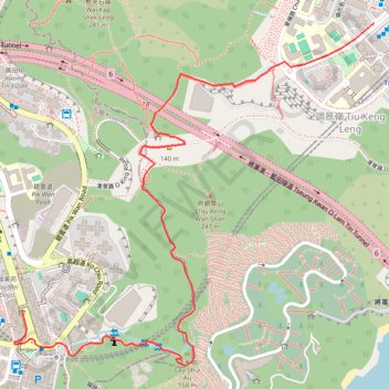
Chiu Keng Wan Shan
- Distance: 3.2 Km
- Elevation gain: 184 m
- Maximum elevation: 168 m
- Elevation loss: 211 m
- Minimum elevation: 10 m
Interactive trail map
Trail profile
- Distance: 3.2 Km
- Elevation gain: 184 m
- Maximum elevation: 168 m
- Elevation loss: 211 m
- Minimum elevation: 10 m
About this trail
Name: Chiu Keng Wan Shan trail, distance, elevation, map, profile, GPS track
Coordinates: 22.29468 114.23946 22.30534 114.25154
Other hiking, mountain biking, running and outdoor activity trails
Click on a trail to view its statistics, map and profile.
Wilson Trail Full Route
China > Hong Kong > Hong Kong Island
Distance: 81.2 Km • Elevation gain: 4,430 m • Maximum elevation: 613 m