Creswick State Forest
Interactive trail map
Trail profile
- Distance: 15.2 Km
- Elevation gain: 237 m
- Maximum elevation: 577 m
- Elevation loss: 237 m
- Minimum elevation: 422 m
About this trail
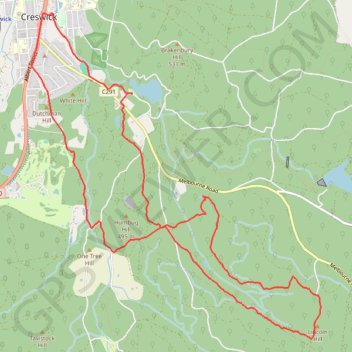
Name: Creswick State Forest trail, distance, elevation, map, profile, GPS track
Start: Saint Georges Street, Creswick, Shire of Hepburn, Victoria, 3363, Australia (-37.43355 143.90765)
End: Saint Georges Street, Creswick, Shire of Hepburn, Victoria, 3363, Australia (-37.43353 143.90765)
Coordinates: -37.46202 143.89288 -37.42421 143.93520
Topography: Victoria topographic map, elevation, terrain
Other hiking, mountain biking, running and outdoor activity trails
Click on a trail to view its statistics, map and profile.
Cosgrave Reservoir - Goldfields
Australia > Victoria > Creswick
Distance: 9.6 Km • Elevation gain: 185 m • Maximum elevation: 563 m