Import a GPX file

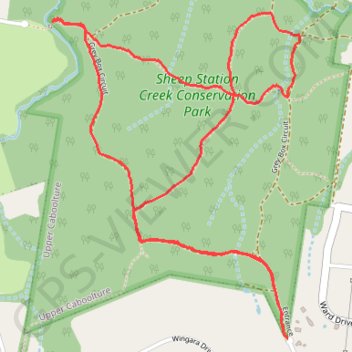
Sheep Station Creek Conservation Park

#Hiking #Loop #SheepStationCreek

  • Distance: 6.4 Km
  • Elevation gain: 73 m
  • Maximum elevation: 54 m
  • Elevation loss: 75 m
  • Minimum elevation: 24 m

Interactive trail map

Trail profile

  • Distance: 6.4 Km
  • Elevation gain: 73 m
  • Maximum elevation: 54 m
  • Elevation loss: 75 m
  • Minimum elevation: 24 m

About this trail

Other hiking, mountain biking, running and outdoor activity trails

Click on a trail to view its statistics, map and profile.

Dayboro - Mount Mee - Kobble Creek

Australia > Queensland > City of Brisbane

Lake Samsonvale. #Bike #Loop #Samsonvale #Mee #Kobble #Brisbane

Distance: 112.5 Km • Elevation gain: 1,817 m • Maximum elevation: 421 m

Dayboro - Wamuran

Australia > Queensland > City of Brisbane

D'Aguilar National Park. #MTB #DAguilar

Distance: 84.6 Km • Elevation gain: 2,030 m • Maximum elevation: 541 m

Gear up for your next adventure:

🔋Solar Power Banks - Charge your phone and GPS using the sun while deep in the bush
🧥Packable Rain Jackets - Breathable waterproof layers for unpredictable mountain weather
🛠️Outdoor Repair Kits - Gear repair kits
🛌Sleeping Mats - Insulated mats for camping comfort
🩹Wilderness First Aid Kits - Comprehensive medical kits tailored for hiking and remote exploration

As an Amazon Associate, this site earns from qualifying purchases at no extra cost to you.