Thank you for supporting this site ❤️
Make a donation
Make a donation
Gear up for your next adventure:
As an Amazon Associate, this site earns from qualifying purchases at no extra cost to you.
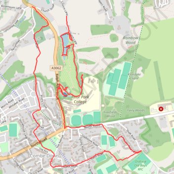
Prior Park, Combe Down, Allotments
- Distance: 6.5 Km
- Elevation gain: 148 m
- Maximum elevation: 163 m
- Elevation loss: 167 m
- Minimum elevation: 46 m
- Moving time: 1 h 45 m
- Moving speed: 3.7 Km/h
- Maximum speed: 9.6 Km/h
- Total time: 2 h 33 m
- Global speed: 2.5 Km/h
Interactive trail map
Thank you for supporting this site ❤️
Make a donation
Make a donation
Gear up for your next adventure:
🎒40L Day Hiking Backpacks - Comfortable packs with hydration support for long days exploring topographic peaks
As an Amazon Associate, this site earns from qualifying purchases at no extra cost to you.
Trail profile
- Distance: 6.5 Km
- Elevation gain: 148 m
- Maximum elevation: 163 m
- Elevation loss: 167 m
- Minimum elevation: 46 m
- Moving time: 1 h 45 m
- Moving speed: 3.7 Km/h
- Maximum speed: 9.6 Km/h
- Total time: 2 h 33 m
- Global speed: 2.5 Km/h
Thank you for supporting this site ❤️
Make a donation
Make a donation
Gear up for your next adventure:
As an Amazon Associate, this site earns from qualifying purchases at no extra cost to you.
About this trail
Name: Prior Park, Combe Down, Allotments trail, distance, elevation, map, profile, GPS track
Coordinates: 51.35927 -2.34927 51.37246 -2.33486
Thank you for supporting this site ❤️
Make a donation
Make a donation
Gear up for your next adventure:
As an Amazon Associate, this site earns from qualifying purchases at no extra cost to you.
Other hiking, mountain biking, running and outdoor activity trails
Click on a trail to view its statistics, map and profile.
Mulberry Park
United Kingdom > England > Bath and North East Somerset > Bath
Distance: 2.1 Km • Elevation gain: 36 m • Maximum elevation: 160 m