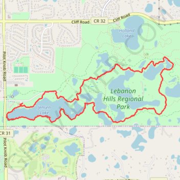
Lebanon Hills Loop via Voyageur Trek in Lebanon Hills Regional Park
The Lebanon Hills Loop is a scenic hike that immerses you in the tranquil beauty of this regional park, offering a peaceful escape from the city. The trail meanders through lush forests, past picturesque lakes, and over boardwalks that enhance the hiking experience. Along the route, you'll encounter varied landscapes, including rolling hills, open prairies, and serene views of lakes like Jensen Lake and O'Brien Lake, making it a great option for both beginner and moderate hikers. #Hiking #Loop #Lake #Forest #Nature
- Distance: 8.3 Km
- Elevation gain: 92 m
- Maximum elevation: 300 m
- Elevation loss: 92 m
- Minimum elevation: 278 m
- Moving time: 1 h 39 m
- Moving speed: 5.0 Km/h
- Maximum speed: 7.4 Km/h
- Total time: 1 h 40 m
- Global speed: 4.9 Km/h
Interactive trail map
Trail profile
- Distance: 8.3 Km
- Elevation gain: 92 m
- Maximum elevation: 300 m
- Elevation loss: 92 m
- Minimum elevation: 278 m
- Moving time: 1 h 39 m
- Moving speed: 5.0 Km/h
- Maximum speed: 7.4 Km/h
- Total time: 1 h 40 m
- Global speed: 4.9 Km/h
About this trail
Name: Lebanon Hills Loop via Voyageur Trek in Lebanon Hills Regional Park trail, distance, elevation, map, profile, GPS track
Start: Barclay Circle, Eagan, Dakota County, Minnesota, 55122, United States (44.77886 -93.16325)
End: Barclay Circle, Eagan, Dakota County, Minnesota, 55122, United States (44.77885 -93.16323)
Coordinates: 44.77622 -93.16636 44.78518 -93.13405