Make a donation
Gear up for your next adventure:
As an Amazon Associate, this site earns from qualifying purchases at no extra cost to you.
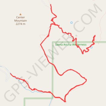
Reynolds Creek, Center Mountain, Lucky Strike Trails
Sierra Ancha Wilderness
- Distance: 20.2 Km
- Elevation gain: 1,133 m
- Maximum elevation: 2,290 m
- Elevation loss: 1,133 m
- Minimum elevation: 1,803 m
- Moving time: 4 h 53 m
- Moving speed: 4.1 Km/h
- Maximum speed: 7.0 Km/h
- Total time: 5 h 41 m
- Global speed: 3.6 Km/h
Interactive trail map
Make a donation
Gear up for your next adventure:
As an Amazon Associate, this site earns from qualifying purchases at no extra cost to you.
Trail profile
- Distance: 20.2 Km
- Elevation gain: 1,133 m
- Maximum elevation: 2,290 m
- Elevation loss: 1,133 m
- Minimum elevation: 1,803 m
- Moving time: 4 h 53 m
- Moving speed: 4.1 Km/h
- Maximum speed: 7.0 Km/h
- Total time: 5 h 41 m
- Global speed: 3.6 Km/h
Make a donation
Gear up for your next adventure:
As an Amazon Associate, this site earns from qualifying purchases at no extra cost to you.
About this trail
Name: Reynolds Creek, Center Mountain, Lucky Strike Trails trail, distance, elevation, map, profile, GPS track
Start: Reynolds Trail, Gila County, Arizona, United States (33.84754 -110.92628)
End: Reynolds Trail, Gila County, Arizona, United States (33.84746 -110.92621)
Coordinates: 33.84013 -110.92628 33.86543 -110.89988
Make a donation
Gear up for your next adventure:
As an Amazon Associate, this site earns from qualifying purchases at no extra cost to you.
Other hiking, mountain biking, running and outdoor activity trails
Click on a trail to view its statistics, map and profile.
Reynolds, Murphy, Rim, Moody Point Trails
United States > Arizona > Gila County
Sierra Ancha Wilderness
Distance: 22.5 Km • Elevation gain: 1,068 m • Maximum elevation: 2,359 m