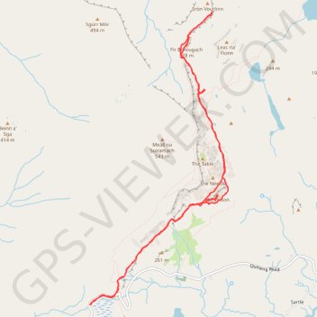
Quiraing
The Prison - The Needle - The Table - Fir Bhreugach - Leac na' Fionn - Sròn Vourlinn
Isle of Skye
- Distance: 9.5 Km
- Elevation gain: 409 m
- Maximum elevation: 348 m
- Elevation loss: 409 m
- Minimum elevation: 253 m
- Moving time: 3 h 7 m
- Moving speed: 3.0 Km/h
- Maximum speed: 6.0 Km/h
- Total time: 4 h 14 m
- Global speed: 2.2 Km/h
Interactive trail map
Trail profile
- Distance: 9.5 Km
- Elevation gain: 409 m
- Maximum elevation: 348 m
- Elevation loss: 409 m
- Minimum elevation: 253 m
- Moving time: 3 h 7 m
- Moving speed: 3.0 Km/h
- Maximum speed: 6.0 Km/h
- Total time: 4 h 14 m
- Global speed: 2.2 Km/h
About this trail
Name: Quiraing trail, distance, elevation, map, profile, GPS track
Start: Quiraing Road, Kilmuir, Highland, Scotland, IV51 9LB, United Kingdom (57.62748 -6.29419)
End: Quiraing Road, Kilmuir, Highland, Scotland, IV51 9LB, United Kingdom (57.62754 -6.29426)
Coordinates: 57.62748 -6.29437 57.65491 -6.27010
Other hiking, mountain biking, running and outdoor activity trails
Click on a trail to view its statistics, map and profile.
Quiraing Loop
United Kingdom > Scotland > Highland
Distance: 7.0 Km • Elevation gain: 375 m • Maximum elevation: 523 m