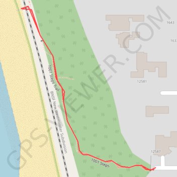
1001 Steps
- Distance: 0.6 Km
- Elevation gain: 32 m
- Maximum elevation: 44 m
- Elevation loss: 33 m
- Minimum elevation: 11 m
Interactive trail map
Trail profile
- Distance: 0.6 Km
- Elevation gain: 32 m
- Maximum elevation: 44 m
- Elevation loss: 33 m
- Minimum elevation: 11 m
About this trail
Name: 1001 Steps trail, distance, elevation, map, profile, GPS track
Coordinates: 49.03054 -122.87556 49.03220 -122.87348
Other hiking, mountain biking, running and outdoor activity trails
Click on a trail to view its statistics, map and profile.
Tsawwassen - Chilliwack
Canada > British Columbia > Metro Vancouver Regional District
Distance: 98.7 Km • Elevation gain: 500 m • Maximum elevation: 126 m