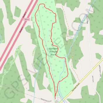
Hanwell Nature Park Loop
Interactive trail map
Trail profile
- Distance: 4.5 Km
- Elevation gain: 38 m
- Maximum elevation: 141 m
- Elevation loss: 38 m
- Minimum elevation: 111 m
About this trail
Name: Hanwell Nature Park Loop trail, distance, elevation, map, profile, GPS track
Coordinates: 45.88825 -66.78194 45.90516 -66.77355
Other hiking, mountain biking, running and outdoor activity trails
Click on a trail to view its statistics, map and profile.
Upper Kingsclear - Coles Island
Canada > New Brunswick > Kingsclear Parish
#Bike #UpperKingsclear #ColesIsland
Distance: 126.9 Km • Elevation gain: 704 m • Maximum elevation: 76 m
Upper Kingsclear - Carters Point
Canada > New Brunswick > Kingsclear Parish
Saint John River. #Bike
Distance: 125.3 Km • Elevation gain: 1,030 m • Maximum elevation: 121 m