Import a GPX file

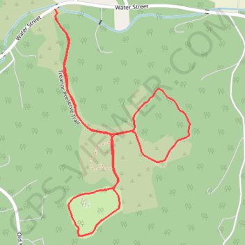
Treanor Preserve Trail

#Hiking #Loop #Nature #Forest

  • Distance: 2.3 Km
  • Elevation gain: 62 m
  • Maximum elevation: 202 m
  • Elevation loss: 63 m
  • Minimum elevation: 151 m
  • Moving time: 32 m 16 s
  • Moving speed: 4.3 Km/h
  • Maximum speed: 5.4 Km/h
  • Total time: 32 m 16 s
  • Global speed: 4.3 Km/h

Interactive trail map

Trail profile

  • Distance: 2.3 Km
  • Elevation gain: 62 m
  • Maximum elevation: 202 m
  • Elevation loss: 63 m
  • Minimum elevation: 151 m
  • Moving time: 32 m 16 s
  • Moving speed: 4.3 Km/h
  • Maximum speed: 5.4 Km/h
  • Total time: 32 m 16 s
  • Global speed: 4.3 Km/h

About this trail

Gear up for your next adventure:

🔪Camping Knives - Multi-purpose outdoor knives
📻Handheld UHF Radios - Critical communication for groups in the Australian outback
🍴Titanium Spork & Cutlery - Indestructible and feather-light eating utensils
🎒40L Day Hiking Backpacks - Comfortable packs with hydration support for long days exploring topographic peaks
👖Convertible Hiking Trousers - Zip-off legs to adapt to changing temperatures throughout the day

As an Amazon Associate, this site earns from qualifying purchases at no extra cost to you.