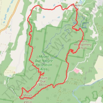
Dial Range Loop (Alt via Ferndene) Mount Montgomery, Gnomon, and Dial
- Distance: 19.5 Km
- Elevation gain: 1,037 m
- Maximum elevation: 481 m
- Elevation loss: 1,038 m
- Minimum elevation: 58 m
- Moving time: 3 h 56 m
- Moving speed: 4.9 Km/h
- Maximum speed: 12.3 Km/h
- Total time: 4 h 3 m
- Global speed: 4.8 Km/h
Interactive trail map
Trail profile
- Distance: 19.5 Km
- Elevation gain: 1,037 m
- Maximum elevation: 481 m
- Elevation loss: 1,038 m
- Minimum elevation: 58 m
- Moving time: 3 h 56 m
- Moving speed: 4.9 Km/h
- Maximum speed: 12.3 Km/h
- Total time: 4 h 3 m
- Global speed: 4.8 Km/h
About this trail
Name: Dial Range Loop (Alt via Ferndene) Mount Montgomery, Gnomon, and Dial trail, distance, elevation, map, profile, GPS track
Start: Montgomery Road, Penguin, Central Coast, Tasmania, 7316, Australia (-41.13832 146.06243)
End: Montgomery Road, Penguin, Central Coast, Tasmania, 7316, Australia (-41.13824 146.06228)
Coordinates: -41.17797 146.02807 -41.13584 146.06583
Topography: Tasmania topographic map, elevation, terrain