Make a donation
Gear up for your next adventure:
As an Amazon Associate, this site earns from qualifying purchases at no extra cost to you.
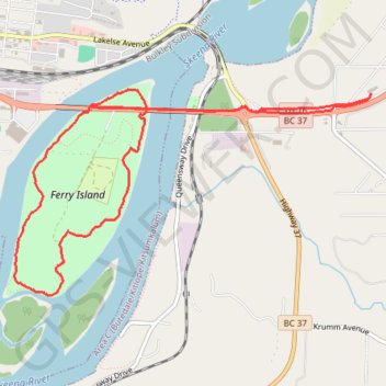
Trace of Trail around Ferry island as well as pedestrian access via the highway bridge and roundabout to the west
Kitimat-Stikine - Easy Run
- Distance: 7.5 Km
- Elevation gain: 141 m
- Maximum elevation: 84 m
- Elevation loss: 142 m
- Minimum elevation: 51 m
- Moving time: 45 m 17 s
- Moving speed: 10.0 Km/h
- Maximum speed: 17.2 Km/h
- Total time: 45 m 17 s
- Global speed: 10.0 Km/h
Interactive trail map
Make a donation
Gear up for your next adventure:
As an Amazon Associate, this site earns from qualifying purchases at no extra cost to you.
Trail profile
- Distance: 7.5 Km
- Elevation gain: 141 m
- Maximum elevation: 84 m
- Elevation loss: 142 m
- Minimum elevation: 51 m
- Moving time: 45 m 17 s
- Moving speed: 10.0 Km/h
- Maximum speed: 17.2 Km/h
- Total time: 45 m 17 s
- Global speed: 10.0 Km/h
Make a donation
Gear up for your next adventure:
As an Amazon Associate, this site earns from qualifying purchases at no extra cost to you.
About this trail
Name: Trace of Trail around Ferry island as well as pedestrian access via the highway bridge and roundabout to the west trail, distance, elevation, map, profile, GPS track
Coordinates: 54.50119 -128.58042 54.51305 -128.54513
Make a donation
Gear up for your next adventure:
As an Amazon Associate, this site earns from qualifying purchases at no extra cost to you.
Other hiking, mountain biking, running and outdoor activity trails
Click on a trail to view its statistics, map and profile.
Terrace - Kitwanga
Canada > British Columbia > Regional District of Kitimat-Stikine > Terrace
Skeena River. #Bike
Distance: 96.5 Km • Elevation gain: 995 m • Maximum elevation: 231 m