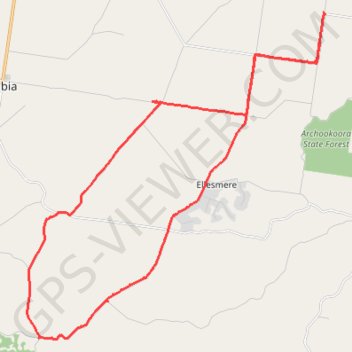
Goodger to Ellesmere
Goodger, Brooklands, Ellesmere, Haly Creek, Archookoora, Queensland
- Distance: 42.8 Km
- Elevation gain: 375 m
- Maximum elevation: 615 m
- Elevation loss: 375 m
- Minimum elevation: 461 m
- Moving time: 2 h 17 m
- Moving speed: 18.6 Km/h
- Maximum speed: 48.6 Km/h
- Total time: 2 h 44 m
- Global speed: 15.6 Km/h
Interactive trail map
Trail profile
- Distance: 42.8 Km
- Elevation gain: 375 m
- Maximum elevation: 615 m
- Elevation loss: 375 m
- Minimum elevation: 461 m
- Moving time: 2 h 17 m
- Moving speed: 18.6 Km/h
- Maximum speed: 48.6 Km/h
- Total time: 2 h 44 m
- Global speed: 15.6 Km/h
About this trail
Name: Goodger to Ellesmere trail, distance, elevation, map, profile, GPS track
Start: Mustons Road, Haly Creek, South Burnett Regional, Queensland, Australia (-26.68268 151.77830)
End: Mustons Road, Haly Creek, South Burnett Regional, Queensland, Australia (-26.68271 151.77827)
Coordinates: -26.77879 151.66602 -26.66607 151.78150
Topography: Queensland topographic map, elevation, terrain
Other hiking, mountain biking, running and outdoor activity trails
Click on a trail to view its statistics, map and profile.
Ushers Hill and Archookoora State Forest loop
Distance: 52.6 Km • Elevation gain: 655 m • Maximum elevation: 563 m
Goodger to Ellesmere and Archookoora State Forest
Goodger, Brooklands, Ellesmere, Haly Creek, Archookoora, Queensland
Distance: 47.8 Km • Elevation gain: 622 m • Maximum elevation: 551 m
Brooklands to Maidenwell
Australia > Queensland > Brooklands
Brooklands, Maidenwell, Tarong, Queensland
Distance: 38.7 Km • Elevation gain: 461 m • Maximum elevation: 544 m
Inverlaw to Kumbia
Inverlaw, Benair, Kumbia, Queensland
Distance: 40.7 Km • Elevation gain: 336 m • Maximum elevation: 537 m
Kumbia to Benair loop
Australia > Queensland > Kumbia
Distance: 30.4 Km • Elevation gain: 273 m • Maximum elevation: 547 m
Oaky Creek Back Road
Distance: 24.6 Km • Elevation gain: 296 m • Maximum elevation: 582 m