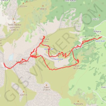
Savin kuk 2313 - Šljeme istočni vrh 2445 - Vrh Šljemena 2455...
- Distance: 13.5 Km
- Elevation gain: 1,283 m
- Maximum elevation: 2,441 m
- Elevation loss: 1,284 m
- Minimum elevation: 1,512 m
- Moving time: 4 h 54 s
- Moving speed: 3.4 Km/h
- Maximum speed: 11.5 Km/h
- Total time: 4 h 45 m
- Global speed: 2.8 Km/h
Interactive trail map
Trail profile
- Distance: 13.5 Km
- Elevation gain: 1,283 m
- Maximum elevation: 2,441 m
- Elevation loss: 1,284 m
- Minimum elevation: 1,512 m
- Moving time: 4 h 54 s
- Moving speed: 3.4 Km/h
- Maximum speed: 11.5 Km/h
- Total time: 4 h 45 m
- Global speed: 2.8 Km/h
About this trail
Name: Savin kuk 2313 - Šljeme istočni vrh 2445 - Vrh Šljemena 2455... trail, distance, elevation, map, profile, GPS track
Coordinates: 43.11285 19.06451 43.12287 19.10414
Other hiking, mountain biking, running and outdoor activity trails
Click on a trail to view its statistics, map and profile.
2022_Yu
Slovenia > Ajdovščina > Žapuže
Distance: 2,457.3 Km • Elevation gain: 32,048 m • Maximum elevation: 1,950 m
MNE-3: Sedlo - Bobotov kuk - Ice Cave - Crno jezero
Montenegro > Žabljak Municipality > Pašina voda > Pošćenski katun
Distance: 14.5 Km • Elevation gain: 985 m • Maximum elevation: 2,416 m