Make a donation
Gear up for your next adventure:
As an Amazon Associate, this site earns from qualifying purchases at no extra cost to you.
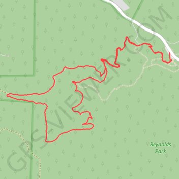
Eagle's View Trail and Raven's Roost Trail Loop in Reynolds Park
The Eagle's View Trail and Raven's Roost Trail Loop in Reynolds Park offers a delightful and moderately challenging hike through a variety of landscapes. As you ascend through meadows and ponderosa pine forests, you'll be treated to sweeping panoramic views of Colorado's Rampart Range and Pikes Peak, especially from the Eagle's View overlook. The trail descends through wooded areas, with opportunities to spot wildlife like Clark's Nutcracker and Stellar Jays, before completing the loop with scenic vistas of the valley and distant plains. #Hiking #Mountain #Forest #Nature #Loop #Overlook
- Distance: 7.3 Km
- Elevation gain: 352 m
- Maximum elevation: 2,488 m
- Elevation loss: 355 m
- Minimum elevation: 2,210 m
- Moving time: 1 h 47 m
- Moving speed: 4.1 Km/h
- Maximum speed: 15.0 Km/h
- Total time: 2 h 8 m
- Global speed: 3.4 Km/h
Interactive trail map
Make a donation
Gear up for your next adventure:
As an Amazon Associate, this site earns from qualifying purchases at no extra cost to you.
Trail profile
- Distance: 7.3 Km
- Elevation gain: 352 m
- Maximum elevation: 2,488 m
- Elevation loss: 355 m
- Minimum elevation: 2,210 m
- Moving time: 1 h 47 m
- Moving speed: 4.1 Km/h
- Maximum speed: 15.0 Km/h
- Total time: 2 h 8 m
- Global speed: 3.4 Km/h
Make a donation
Gear up for your next adventure:
As an Amazon Associate, this site earns from qualifying purchases at no extra cost to you.
About this trail
Name: Eagle's View Trail and Raven's Roost Trail Loop in Reynolds Park trail, distance, elevation, map, profile, GPS track
End: Fox Trot Trail, Jefferson County, Colorado, United States (39.46642 -105.23918)
Coordinates: 39.45899 -105.25867 39.46862 -105.23902
Make a donation
Gear up for your next adventure:
As an Amazon Associate, this site earns from qualifying purchases at no extra cost to you.