Make a donation
Gear up for your next adventure:
As an Amazon Associate, this site earns from qualifying purchases at no extra cost to you.
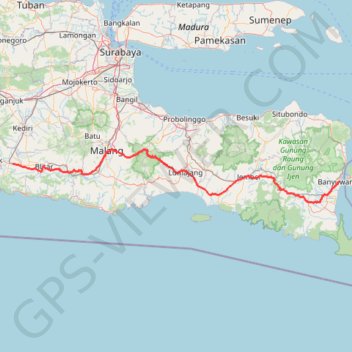
BENTANGJAWA2024_FINAL
- Distance: 367.5 Km
- Elevation gain: 4,516 m
- Maximum elevation: 2,460 m
- Elevation loss: 4,601 m
- Minimum elevation: 8 m
Interactive trail map
Make a donation
Gear up for your next adventure:
As an Amazon Associate, this site earns from qualifying purchases at no extra cost to you.
Trail profile
- Distance: 367.5 Km
- Elevation gain: 4,516 m
- Maximum elevation: 2,460 m
- Elevation loss: 4,601 m
- Minimum elevation: 8 m
Make a donation
Gear up for your next adventure:
As an Amazon Associate, this site earns from qualifying purchases at no extra cost to you.
About this trail
Name: BENTANGJAWA2024_FINAL trail, distance, elevation, map, profile, GPS track
Coordinates: -8.36952 111.93542 -7.97421 114.37604
Make a donation
Gear up for your next adventure:
As an Amazon Associate, this site earns from qualifying purchases at no extra cost to you.
Other hiking, mountain biking, running and outdoor activity trails
Click on a trail to view its statistics, map and profile.
BENTANGJAWA2024_FINAL
Indonesia > West Java > Sukabumi > Tegalbuleud > Panaruban
Distance: 1,147.2 Km • Elevation gain: 12,308 m • Maximum elevation: 2,460 m
Benjaw day 3
Indonesia > Central Java > Kebumen > Bumirejo
Distance: 356.8 Km • Elevation gain: 4,241 m • Maximum elevation: 588 m
Benjaw day 3
Indonesia > Central Java > Kebumen > Bumirejo
Distance: 356.8 Km • Elevation gain: 4,241 m • Maximum elevation: 588 m