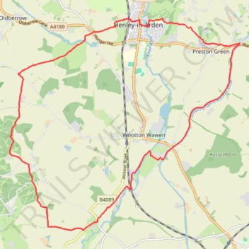
Henley-in-Arden 🔁 Little Alne
- Distance: 18.3 Km
- Elevation gain: 175 m
- Maximum elevation: 110 m
- Elevation loss: 175 m
- Minimum elevation: 54 m
- Moving time: 2 h 1 m
- Moving speed: 9.1 Km/h
- Maximum speed: 14.8 Km/h
- Total time: 2 h 5 m
- Global speed: 8.8 Km/h
Interactive trail map
Trail profile
- Distance: 18.3 Km
- Elevation gain: 175 m
- Maximum elevation: 110 m
- Elevation loss: 175 m
- Minimum elevation: 54 m
- Moving time: 2 h 1 m
- Moving speed: 9.1 Km/h
- Maximum speed: 14.8 Km/h
- Total time: 2 h 5 m
- Global speed: 8.8 Km/h
About this trail
Name: Henley-in-Arden 🔁 Little Alne trail, distance, elevation, map, profile, GPS track
Coordinates: 52.24752 -1.82484 52.29191 -1.74594
Other hiking, mountain biking, running and outdoor activity trails
Click on a trail to view its statistics, map and profile.
Henley-in-Arden to Shrewley trailrun
United Kingdom > England > Warwickshire > Stratford-on-Avon > Henley-in-Arden
Distance: 19.6 Km • Elevation gain: 284 m • Maximum elevation: 124 m
Alcester trail run
United Kingdom > England > Warwickshire > Stratford-on-Avon > Alcester > Arrow > Oversley Green
Morning Run
Distance: 22.3 Km • Elevation gain: 277 m • Maximum elevation: 124 m