Thank you for supporting this site ❤️
Make a donation
Make a donation
Gear up for your next adventure:
As an Amazon Associate, this site earns from qualifying purchases at no extra cost to you.
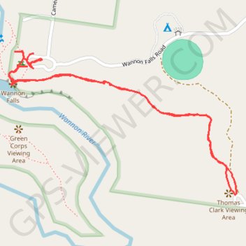
Wannon Falls Walk
- Distance: 2.4 Km
- Elevation gain: 68 m
- Maximum elevation: 158 m
- Elevation loss: 65 m
- Minimum elevation: 112 m
- Moving time: 32 m 59 s
- Moving speed: 4.3 Km/h
- Maximum speed: 16.8 Km/h
- Total time: 40 m 13 s
- Global speed: 3.5 Km/h
Interactive trail map
Thank you for supporting this site ❤️
Make a donation
Make a donation
Gear up for your next adventure:
As an Amazon Associate, this site earns from qualifying purchases at no extra cost to you.
Trail profile
- Distance: 2.4 Km
- Elevation gain: 68 m
- Maximum elevation: 158 m
- Elevation loss: 65 m
- Minimum elevation: 112 m
- Moving time: 32 m 59 s
- Moving speed: 4.3 Km/h
- Maximum speed: 16.8 Km/h
- Total time: 40 m 13 s
- Global speed: 3.5 Km/h
Thank you for supporting this site ❤️
Make a donation
Make a donation
Gear up for your next adventure:
As an Amazon Associate, this site earns from qualifying purchases at no extra cost to you.
About this trail
Name: Wannon Falls Walk trail, distance, elevation, map, profile, GPS track
Coordinates: -37.67913 141.84150 -37.67518 141.84940
Topography: Victoria topographic map, elevation, terrain
Thank you for supporting this site ❤️
Make a donation
Make a donation
Gear up for your next adventure:
As an Amazon Associate, this site earns from qualifying purchases at no extra cost to you.
Other hiking, mountain biking, running and outdoor activity trails
Click on a trail to view its statistics, map and profile.
Wannon Falls
Distance: 0.5 Km • Elevation gain: 20 m • Maximum elevation: 129 m