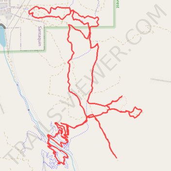
Santaquin Canyon MTB trails - Uinta-Wasatch-Cache National Forest
- Distance: 18.9 Km
- Elevation gain: 785 m
- Maximum elevation: 2,009 m
- Elevation loss: 784 m
- Minimum elevation: 1,606 m
- Moving time: 2 h 29 m
- Moving speed: 7.6 Km/h
- Maximum speed: 38.9 Km/h
- Total time: 2 h 48 m
- Global speed: 6.7 Km/h
Interactive trail map
Trail profile
- Distance: 18.9 Km
- Elevation gain: 785 m
- Maximum elevation: 2,009 m
- Elevation loss: 784 m
- Minimum elevation: 1,606 m
- Moving time: 2 h 29 m
- Moving speed: 7.6 Km/h
- Maximum speed: 38.9 Km/h
- Total time: 2 h 48 m
- Global speed: 6.7 Km/h
About this trail
Name: Santaquin Canyon MTB trails - Uinta-Wasatch-Cache National Forest trail, distance, elevation, map, profile, GPS track
Start: Silver King Trail, Utah County, Utah, 84655, United States (39.93925 -111.76846)
End: Silver King Trail, Utah County, Utah, 84655, United States (39.93925 -111.76842)
Coordinates: 39.93594 -111.77487 39.96055 -111.75191