Thank you for supporting this site ❤️
Make a donation
Make a donation
Gear up for your next adventure:
As an Amazon Associate, this site earns from qualifying purchases at no extra cost to you.
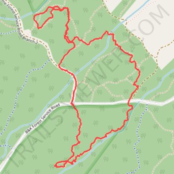
Loop hike on Oxygen Trail and Elphinstone Health Trail
- Distance: 4.2 Km
- Elevation gain: 156 m
- Maximum elevation: 358 m
- Elevation loss: 157 m
- Minimum elevation: 253 m
- Moving time: 1 h 26 m
- Moving speed: 2.9 Km/h
- Maximum speed: 6.2 Km/h
- Total time: 1 h 40 m
- Global speed: 2.5 Km/h
Interactive trail map
Thank you for supporting this site ❤️
Make a donation
Make a donation
Gear up for your next adventure:
As an Amazon Associate, this site earns from qualifying purchases at no extra cost to you.
Trail profile
- Distance: 4.2 Km
- Elevation gain: 156 m
- Maximum elevation: 358 m
- Elevation loss: 157 m
- Minimum elevation: 253 m
- Moving time: 1 h 26 m
- Moving speed: 2.9 Km/h
- Maximum speed: 6.2 Km/h
- Total time: 1 h 40 m
- Global speed: 2.5 Km/h
Thank you for supporting this site ❤️
Make a donation
Make a donation
Gear up for your next adventure:
As an Amazon Associate, this site earns from qualifying purchases at no extra cost to you.
About this trail
Name: Loop hike on Oxygen Trail and Elphinstone Health Trail trail, distance, elevation, map, profile, GPS track
Coordinates: 49.43479 -123.61461 49.44397 -123.60530
Thank you for supporting this site ❤️
Make a donation
Make a donation
Gear up for your next adventure:
As an Amazon Associate, this site earns from qualifying purchases at no extra cost to you.