
North Mountain, North Lake, South Mountain and South Lake Loop
Loop hike above North Lake and South Lake via North Mountain, Escarpment Trail, Newmans Ledge, Lookout Rock, Sunset Rock, Mountain House Trail, Catskill Mountain House Site, South Mountain and Schutt Road in the Windham-Blackhead Range Wilderness, the Kaaterskill Wild Forest and the Catskill Park. #Hiking #Loop #Mountain #Lake #Nature #Forest #Rock #Overlook #Wilderness
- Distance: 10.0 Km
- Elevation gain: 335 m
- Maximum elevation: 796 m
- Elevation loss: 361 m
- Minimum elevation: 640 m
- Moving time: 3 h 6 m
- Moving speed: 3.2 Km/h
- Maximum speed: 5.2 Km/h
- Total time: 3 h 16 m
- Global speed: 3.0 Km/h
Interactive trail map
Trail profile
- Distance: 10.0 Km
- Elevation gain: 335 m
- Maximum elevation: 796 m
- Elevation loss: 361 m
- Minimum elevation: 640 m
- Moving time: 3 h 6 m
- Moving speed: 3.2 Km/h
- Maximum speed: 5.2 Km/h
- Total time: 3 h 16 m
- Global speed: 3.0 Km/h
About this trail
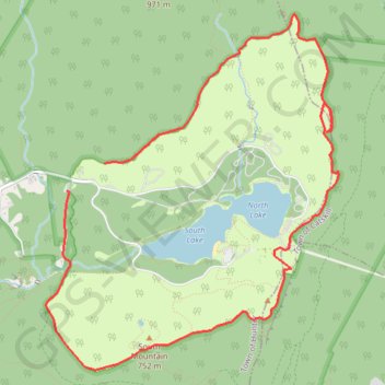
Name: North Mountain, North Lake, South Mountain and South Lake Loop trail, distance, elevation, map, profile, GPS track
Start: North Lake Road, Town of Hunter, Greene County, New York, 12463, United States (42.20290 -74.05443)
Coordinates: 42.18667 -74.06063 42.21459 -74.02964