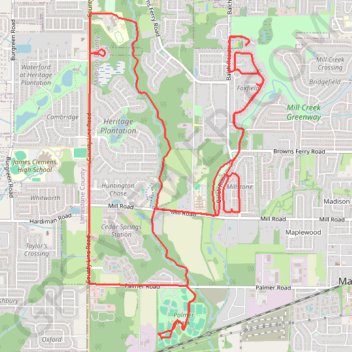
13 Mile Bike, Madison, AL
- Distance: 21.0 Km
- Elevation gain: 128 m
- Maximum elevation: 222 m
- Elevation loss: 128 m
- Minimum elevation: 195 m
- Moving time: 1 h 6 m
- Moving speed: 18.8 Km/h
- Maximum speed: 35.1 Km/h
- Total time: 1 h 6 m
- Global speed: 18.8 Km/h
Interactive trail map
Trail profile
- Distance: 21.0 Km
- Elevation gain: 128 m
- Maximum elevation: 222 m
- Elevation loss: 128 m
- Minimum elevation: 195 m
- Moving time: 1 h 6 m
- Moving speed: 18.8 Km/h
- Maximum speed: 35.1 Km/h
- Total time: 1 h 6 m
- Global speed: 18.8 Km/h
About this trail
Name: 13 Mile Bike, Madison, AL trail, distance, elevation, map, profile, GPS track
Coordinates: 34.68655 -86.78652 34.72175 -86.76352
Other hiking, mountain biking, running and outdoor activity trails
Click on a trail to view its statistics, map and profile.
10 Mile Run, Madison AL
United States > Alabama > Madison County > Madison
Lunch Run
Distance: 16.5 Km • Elevation gain: 100 m • Maximum elevation: 222 m
Bradford Creek Greenway
United States > Alabama > Madison County > Madison
Distance: 7.3 Km • Elevation gain: 37 m • Maximum elevation: 214 m
Bradford Creek Greenway
United States > Alabama > Madison County > Madison
Distance: 8.1 Km • Elevation gain: 37 m • Maximum elevation: 215 m
Bicycle-Madison AL
United States > Alabama > Madison County > Madison
Afternoon Ride
Distance: 16.6 Km • Elevation gain: 103 m • Maximum elevation: 222 m