Import a GPX file

Lake Erie State Park Trail

Hiking

  • Distance: 4.1 Km
  • Elevation gain: 32 m
  • Maximum elevation: 192 m
  • Elevation loss: 31 m
  • Minimum elevation: 176 m
  • Moving time: 59 m 11 s
  • Moving speed: 4.1 Km/h
  • Maximum speed: 7.8 Km/h
  • Total time: 1 h 6 m
  • Global speed: 3.7 Km/h

Interactive trail map

Trail profile

  • Distance: 4.1 Km
  • Elevation gain: 32 m
  • Maximum elevation: 192 m
  • Elevation loss: 31 m
  • Minimum elevation: 176 m
  • Moving time: 59 m 11 s
  • Moving speed: 4.1 Km/h
  • Maximum speed: 7.8 Km/h
  • Total time: 1 h 6 m
  • Global speed: 3.7 Km/h

About this trail
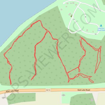
Name: Lake Erie State Park Trail trail, distance, elevation, map, profile, GPS track

Start: East Lake Road, Town of Portland, Chautauqua County, New York, 14716, United States (42.42163 -79.43444)

End: East Lake Road, Town of Portland, Chautauqua County, New York, 14716, United States (42.42181 -79.43441)

Coordinates: 42.41939 -79.43958 42.42261 -79.43298

Gear up for your next adventure:

⌚Altimeter Barometer Watches - Outdoor watches with built-in sensors to track altitude changes and weather shifts
🔭Compact Hiking Binoculars - Lightweight optics for scouting routes or birdwatching
🛠️Outdoor Repair Kits - Gear repair kits
⛺Ultralight Solo Tents - Compact shelters for multi-day topographic surveying expeditions
🧳Outdoor Travel Organizers - Gear organization accessories

As an Amazon Associate, this site earns from qualifying purchases at no extra cost to you.