Fisher Point via Fay Canyon
Mountain Bike in Coconino National Forest via Fay Canyon. #MTB #Canyon #Mountain #Forest #Nature
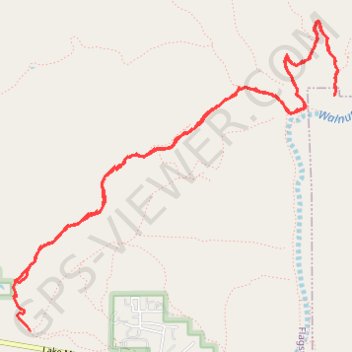
- Distance: 10.9 Km
- Elevation gain: 294 m
- Maximum elevation: 2,138 m
- Elevation loss: 268 m
- Minimum elevation: 2,019 m
- Moving time: 2 h 7 m
- Moving speed: 5.1 Km/h
- Maximum speed: 17.3 Km/h
- Total time: 2 h 36 m
- Global speed: 4.2 Km/h
Interactive trail map
Trail profile
- Distance: 10.9 Km
- Elevation gain: 294 m
- Maximum elevation: 2,138 m
- Elevation loss: 268 m
- Minimum elevation: 2,019 m
- Moving time: 2 h 7 m
- Moving speed: 5.1 Km/h
- Maximum speed: 17.3 Km/h
- Total time: 2 h 36 m
- Global speed: 4.2 Km/h
About this trail
Name: Fisher Point via Fay Canyon trail, distance, elevation, map, profile, GPS track
Start: Fay Canyon, Flagstaff, Coconino County, Arizona, United States (35.13868 -111.62361)
End: Fay Canyon, Flagstaff, Coconino County, Arizona, 86005, United States (35.13510 -111.62230)
Coordinates: 35.13510 -111.62375 35.15726 -111.59545