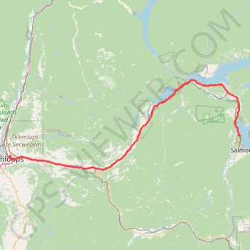
Kamloops - Salmon Arm
Interactive trail map
Trail profile
- Distance: 102.1 Km
- Elevation gain: 824 m
- Maximum elevation: 495 m
- Elevation loss: 815 m
- Minimum elevation: 345 m
About this trail
Name: Kamloops - Salmon Arm trail, distance, elevation, map, profile, GPS track
End: Pierres Point Road, Switsemalph 6, British Columbia, V1E 3A2, Canada (50.73901 -119.31503)
Coordinates: 50.64430 -120.32505 50.89275 -119.31503
Other hiking, mountain biking, running and outdoor activity trails
Click on a trail to view its statistics, map and profile.
Salmon Arm - Sicamous
Canada > British Columbia > Salmon Arm > Switsemalph 6
Lake Shuswap. #Bike
Distance: 40.6 Km • Elevation gain: 456 m • Maximum elevation: 501 m
Cache Creek - Kamloops
Canada > British Columbia > Thompson-Nicola Regional District > Cache Creek
Distance: 86.9 Km • Elevation gain: 1,114 m • Maximum elevation: 736 m
Mount Morrisey Backcountry Ski trails
Canada > British Columbia > Thompson-Nicola Regional District > Area P (Rivers and the Peaks)
Got a little off route at top of fisher and on bruin romp
Distance: 9.9 Km • Elevation gain: 50 m • Maximum elevation: 1,644 m
Sun Peaks Nordic Backcountry Ski Trails
Canada > British Columbia > Thompson-Nicola Regional District > Sun Peaks Mountain Resort Municipality > Sun Peaks
Distance: 18.0 Km • Elevation gain: 368 m • Maximum elevation: 1,443 m