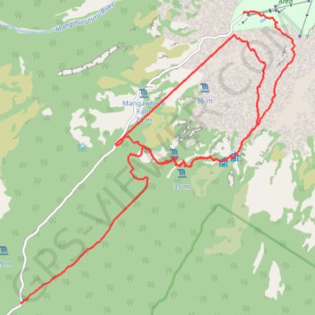
Import a GPX file

Blyth Hut

19-JUN-07

  • Distance: 24.5 Km
  • Elevation gain: 846 m
  • Maximum elevation: 1,728 m
  • Elevation loss: 1,560 m
  • Minimum elevation: 920 m

Interactive trail map

Trail profile

  • Distance: 24.5 Km
  • Elevation gain: 846 m
  • Maximum elevation: 1,728 m
  • Elevation loss: 1,560 m
  • Minimum elevation: 920 m
👉 Easily get elevation data in JSON, GeoTIFF and KML formats using Elevation API
Thank you for supporting this site ❤️
Make a donation

Gear up for your next adventure:

As an Amazon Associate, this site earns from qualifying purchases at no extra cost to you.

About this trail

Other hiking, mountain biking, running and outdoor activity trails

Click on a trail to view its statistics, map and profile.

Tongariro - Pipiriki

New Zealand > Manawatū-Whanganui > Ruapehu District

Tongariro National Park. #Bike #Road #Forest #Mountain #Nature #Tongariro

Distance: 81.5 Km • Elevation gain: 988 m • Maximum elevation: 889 m

Gear up for your next adventure:

📟Satellite Messengers - Two-way satellite communication to stay in touch beyond the cellular grid
🪑Portable Backpacking Chairs - A comfortable seat for studying maps at the end of the day
💧Personal Water Filters - Drink safely from streams and lakes identified on your map
🛠️Outdoor Repair Kits - Gear repair kits
🎨Portable Watercolor Kits - Paint the landscapes and topographic views you discover

As an Amazon Associate, this site earns from qualifying purchases at no extra cost to you.