Thank you for supporting this site ❤️
Make a donation
Make a donation
Gear up for your next adventure:
As an Amazon Associate, this site earns from qualifying purchases at no extra cost to you.
Grapevine Canyon
Interactive trail map
Thank you for supporting this site ❤️
Make a donation
Make a donation
Gear up for your next adventure:
As an Amazon Associate, this site earns from qualifying purchases at no extra cost to you.
Trail profile
- Distance: 2.8 Km
- Elevation gain: 152 m
- Maximum elevation: 857 m
- Elevation loss: 21 m
- Minimum elevation: 724 m
Thank you for supporting this site ❤️
Make a donation
Make a donation
Gear up for your next adventure:
As an Amazon Associate, this site earns from qualifying purchases at no extra cost to you.
About this trail
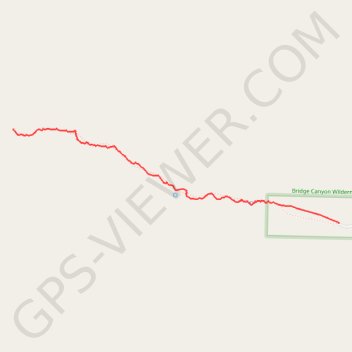
Name: Grapevine Canyon trail, distance, elevation, map, profile, GPS track
Start: Grapevine Canyon Trail, Clark County, Nevada, United States (35.22589 -114.68186)
End: Grapevine Canyon Trail, Clark County, Nevada, United States (35.23177 -114.70668)
Coordinates: 35.22589 -114.70669 35.23179 -114.68186
Thank you for supporting this site ❤️
Make a donation
Make a donation
Gear up for your next adventure:
As an Amazon Associate, this site earns from qualifying purchases at no extra cost to you.