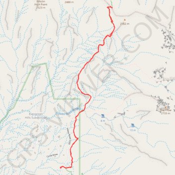
Piedra Lisa South Trail in Sandia Mountain Wilderness
The Piedra Lisa South Trail is a delightful hiking experience that showcases the beauty of New Mexico's landscape. As you ascend, you'll be treated to panoramic views of Albuquerque and the surrounding mountains, with the trail winding through charming sections of wildflowers and pine trees. Whether you're an avid hiker or just looking for a peaceful escape, this trail offers a perfect blend of scenic beauty and a rewarding workout. #Hiking #Mountain #Forest #Nature
- Distance: 7.0 Km
- Elevation gain: 391 m
- Maximum elevation: 2,476 m
- Elevation loss: 391 m
- Minimum elevation: 2,112 m
- Moving time: 2 h 3 m
- Moving speed: 3.4 Km/h
- Maximum speed: 6.8 Km/h
- Total time: 2 h 36 m
- Global speed: 2.7 Km/h
Interactive trail map
Trail profile
- Distance: 7.0 Km
- Elevation gain: 391 m
- Maximum elevation: 2,476 m
- Elevation loss: 391 m
- Minimum elevation: 2,112 m
- Moving time: 2 h 3 m
- Moving speed: 3.4 Km/h
- Maximum speed: 6.8 Km/h
- Total time: 2 h 36 m
- Global speed: 2.7 Km/h
About this trail
Name: Piedra Lisa South Trail in Sandia Mountain Wilderness trail, distance, elevation, map, profile, GPS track
Coordinates: 35.22296 -106.48353 35.24463 -106.47461
Other hiking, mountain biking, running and outdoor activity trails
Click on a trail to view its statistics, map and profile.
Piedra Lisa North Trail - Sandia Mountain Wilderness
United States > New Mexico > Sandoval County
Distance: 12.3 Km • Elevation gain: 697 m • Maximum elevation: 2,475 m