Thank you for supporting this site ❤️
Make a donation
Make a donation
Gear up for your next adventure:
As an Amazon Associate, this site earns from qualifying purchases at no extra cost to you.
Harte Trail
Interactive trail map
Thank you for supporting this site ❤️
Make a donation
Make a donation
Gear up for your next adventure:
As an Amazon Associate, this site earns from qualifying purchases at no extra cost to you.
Trail profile
- Distance: 12.6 Km
- Elevation gain: 14 m
- Maximum elevation: 240 m
- Elevation loss: 14 m
- Minimum elevation: 235 m
Thank you for supporting this site ❤️
Make a donation
Make a donation
Gear up for your next adventure:
As an Amazon Associate, this site earns from qualifying purchases at no extra cost to you.
About this trail
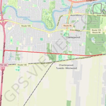
Name: Harte Trail trail, distance, elevation, map, profile, GPS track
Start: Perimeter Highway, Ridgewood West, Winnipeg, Manitoba, R3R 2H3, Canada (49.84679 -97.32353)
End: Perimeter Highway, Ridgewood West, Winnipeg, Manitoba, R3R 2H3, Canada (49.84679 -97.32353)
Coordinates: 49.84425 -97.32353 49.84746 -97.23662
Thank you for supporting this site ❤️
Make a donation
Make a donation
Gear up for your next adventure:
As an Amazon Associate, this site earns from qualifying purchases at no extra cost to you.