Sawmill Snowshoe Loop
Peter Lougheed Provincial Park. #Snowshoeing #Loop #PeterLougheed
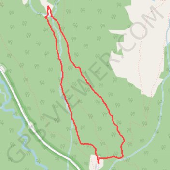
- Distance: 5.2 Km
- Elevation gain: 174 m
- Maximum elevation: 1,974 m
- Elevation loss: 174 m
- Minimum elevation: 1,825 m
Interactive trail map
Trail profile
- Distance: 5.2 Km
- Elevation gain: 174 m
- Maximum elevation: 1,974 m
- Elevation loss: 174 m
- Minimum elevation: 1,825 m
About this trail
Name: Sawmill Snowshoe Loop trail, distance, elevation, map, profile, GPS track
Start: Sawmill Loop, Kananaskis Improvement District, Alberta, Canada (50.74860 -115.24522)
End: Sawmill Loop, Kananaskis Improvement District, Alberta, Canada (50.74860 -115.24522)
Coordinates: 50.74860 -115.25519 50.76716 -115.24049